What Will You See on a Santa Barbara Helicopter Tour?

What you see on a Santa Barbara helicopter tour depends almost entirely on which of the two routes you book, so here is the honest, landmark by landmark version: what the coastline route shows you, what the downtown route adds, and the one thing both routes deliberately leave out. As an aerial photographer who has shot this coast from a cabin window more times than I can count, I can tell you the view changes more by which of the two flights you book than by the day you fly. Below is exactly what fills the window on each of these aerial tours of the Santa Barbara coast, landmark by landmark, with no rounding up.
Quick answer
You'll see the Pacific coastline, Goleta Point and the Santa Ynez Mountains on every flight, the harbor and downtown's red-tile grid only on the longer route, and the Channel Islands only as a shape on the horizon, since neither flight crosses to them. What you get depends less on the weather than on which of the two routes you book.
Key takeaways
- Both flights show the coastline, UCSB's campus and the Santa Ynez Mountains, that part never changes
- Only the Downtown Santa Barbara Helicopter Tour adds the harbor, Stearns Wharf and the Courthouse's El Mirador tower
- Neither flight crosses to the Channel Islands. They're a shape on the horizon, roughly 20 miles out, not a stop on the route
- Whales are seasonal and never guaranteed on a 6 or 12-minute flight, unlike the dedicated whale-watching boats out of the harbor
- Which side of the cabin you get is a request, not a choice, since seats are assigned the same way described in our first-flight guide
- The longer flights on the operator's own list add Lake Cachuma, Lizard Mouth Rock, Solvang and Nojoqui Falls, none of which are on the two flights compared here
The Two Flights and What Each One Shows You
The coastline route and the downtown route share the same first few minutes, then diverge. Both are covered landmark by landmark below.
 from $69
 Santa Barbara Beach & Coastline Helicopter Tour
A scenic 6-minute helicopter ride along the California coastline — fly over UCSB's campus and Campus Lagoon, Goleta Point, Goleta Beach, and soak in panoramic views of the…
- 6-minute coastal helicopter ride
- Fly over UCSB campus and Campus Lagoon
- Views of Goleta Beach and Goleta Point
- Santa Ynez Mountains and Channel Islands visible
 from $149
 Downtown Santa Barbara Helicopter Tour
A 12-minute private helicopter tour that extends the coastline flight into downtown Santa Barbara — sweeping views of the harbor, mountains, beaches, and the Channel Islands, with the…
- 12-minute private helicopter tour
- Downtown Santa Barbara from above
- Harbor, mountains, beaches and Channel Islands
- Wheelchair accessible
The View in One Paragraph
Both flights lift off from Santa Barbara Airport and immediately show you the coastline: UCSB's campus on its oceanfront mesa, Campus Lagoon, Goleta Point and Goleta Beach, with the Santa Ynez Mountains standing as a green wall to the north. From there the two routes split. The 6-minute coastline flight turns back along the shoreline.
The 12-minute downtown flight continues on into the city, adding the harbor, Stearns Wharf and the red-tile rooftops of downtown before it loops back.
The table below sorts every landmark by how reliably you'll actually see it, not by how it sounds in a brochure.
| Landmark | Where in Santa Barbara | How likely |
|---|---|---|
| UCSB campus and Campus Lagoon | Coastal mesa west of Goleta | Every flight |
| Goleta Point and Goleta Beach | Along the coastline west of the airport | Every flight |
| Santa Ynez Mountains | Northern backdrop above the whole route | Every flight |
| Santa Barbara Harbor and breakwater | Downtown waterfront | Downtown flight only |
| Stearns Wharf | Foot of State Street | Downtown flight only |
| Santa Barbara County Courthouse and El Mirador tower | Downtown city grid | Downtown flight only |
| Riviera hillside and foothills | Above downtown, north side | Downtown flight only |
| Channel Islands (horizon only) | Roughly 20 miles across the channel | Clear days only, and always distant |
| Whales (gray or humpback, seasonal) | Santa Barbara Channel | Lucky-day sighting, season dependent |
| Lake Cachuma and Lizard Mouth Rock | Inland, past the Santa Ynez Mountains | Longer operator flights only, not the two compared here |
Nothing on that list is guaranteed by weather alone. The split that actually matters is which flight you book, since the coastline route physically never reaches downtown, the harbor, or the mountains' far side.
The Coastline Route, Landmark by Landmark
This is the view on the Santa Barbara Beach & Coastline Helicopter Tour, 6 minutes door to door. It stays low and close to the shoreline for its entire length, which is part of why it's the shorter and less expensive of the two.
UCSB and Campus Lagoon
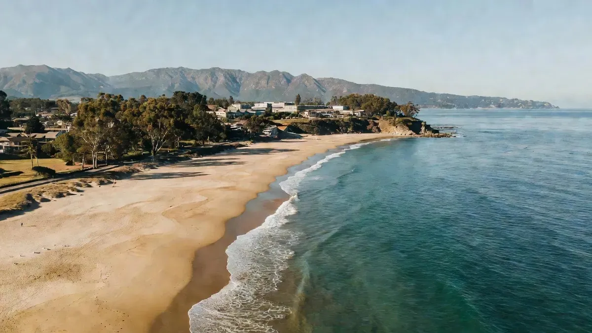
The flight opens over UC Santa Barbara's campus, built out on its own coastal mesa with the Pacific on three sides. Campus Lagoon sits right against the edge of it, a pocket of calm water separated from the open ocean by a narrow sandspit, easy to pick out from the air even on a first pass.
Goleta Point and Goleta Beach
West of campus the shoreline curves out to Goleta Point before opening into the wide sweep of Goleta Beach County Park, one of the longer stretches of open sand on this part of the coast. From altitude the color shift in the water, from deep blue offshore to pale green over the sandbar, is more visible than it ever is from the beach itself.
The airport, eucalyptus groves and the mountain wall
Looking inland, the airport's own runways are visible below, bordered by the eucalyptus groves that line much of this stretch of coast. To the north the Santa Ynez Mountains rise as a continuous green wall, running the length of the flight and giving every photo on this route the same recognizable backdrop. The full pricing and booking details for this route sit in our coastline flight guide.
The Downtown Route, Landmark by Landmark
The Downtown Santa Barbara Helicopter Tour flies the coastline route above, then keeps going, adding downtown, the harbor and the hillside above the city over its full 12 minutes.
The harbor and Stearns Wharf
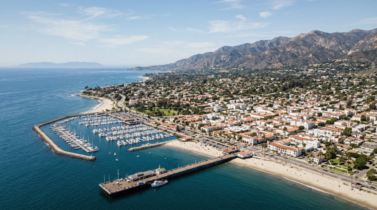
Santa Barbara Harbor comes into view with its breakwater curving out into the channel, small craft moored in neat rows inside it. Just up the shoreline, Stearns Wharf extends out from the foot of State Street, the pier's full length and the buildings along it laid out clearly from directly above in a way no ground-level photo captures.
The red-tile city grid and the Courthouse tower
From there the route crosses over downtown itself, where the Spanish Colonial red-tile roofline runs block after block in a genuinely uniform pattern. The Santa Barbara County Courthouse stands out from the rest of the grid immediately, its El Mirador clock tower the tallest thing in the frame at that point in the flight and the easiest single landmark to spot from altitude.
| Landmark | What to look for |
|---|---|
| Santa Barbara Harbor | Curved breakwater, rows of moored boats |
| Stearns Wharf | Long pier extending straight out from State Street |
| Downtown city grid | Uniform red-tile Spanish Colonial rooftops |
| County Courthouse, El Mirador tower | Tallest structure downtown, clock tower visible from altitude |
| Riviera hillside | Terraced hillside north of downtown, homes visible among the trees |
The Riviera hillside and the foothills
The flight closes with a pass over the Riviera, the terraced hillside neighborhood north of downtown, and the foothills rising behind it before the route turns back toward the airport. It's the one part of the flight where the view is more architecture and hillside than coastline. The full route and pricing sit in our downtown flight guide.
What the Longer Flights Add
The operator publishes several longer flights beyond the two we compare here, and each one reaches further inland or further up the coast. None of these are the coastline or downtown tour. They're separate, longer products with their own pricing, listed here so you know what exists if 6 or 12 minutes turns out not to be enough.
- The Ynez Crossing and Ultimate Excursion, the operator's longer routes, continue past the Santa Ynez Mountains to Lake Cachuma and Lizard Mouth Rock, terrain neither of our two flights reaches
- The hour-long private charter goes furthest, adding Solvang's Danish-style town center and Nojoqui Falls Park, both well inland of anything on the coastline or downtown route
- A night flight exists separately for downtown and the coastline after dark, a different view entirely from the daytime routes covered here
- None of these longer options are part of the two fares we compare on this site, so treat this list as context for what's possible with this operator, not as a promise about either flight above
The Channel Islands, and Why You Do Not Fly to Them
This is the single biggest misconception about flying here, so it's worth stating plainly: neither the coastline flight nor the downtown flight crosses to the Channel Islands. They're a shape on the horizon on a clear day, not a destination on the route. The northern islands sit roughly 20 miles across the Santa Barbara Channel, with Anacapa, the closest, a little over 12 miles out at its shortest crossing.
On a hazy day they may not be visible at all, and the coastal marine layer covered in our best time to fly guide is the biggest reason clarity varies morning to morning.
Even a flight built specifically to reach the islands would be bound by real limits once it got there. The Channel Islands National Marine Sanctuary sets a minimum altitude of 1,000 feet above the water within one nautical mile of any island, a rule meant to keep aircraft from disturbing marine mammals and seabirds. Separately, FAA Advisory Circular 91-36D asks pilots to stay at least 2,000 feet above land administered by the National Park Service, which covers the four northern islands: Anacapa, Santa Cruz, Santa Rosa and San Miguel.
| Rule | Minimum altitude | Applies to |
|---|---|---|
| Channel Islands National Marine Sanctuary overflight rule | 1,000 feet above water | Within one nautical mile of any island |
| FAA Advisory Circular 91-36D | 2,000 feet above ground | Land administered by the National Park Service, the four northern islands |
Altitude over the mainland is shaped by a different set of constraints. Santa Barbara Airport runs a voluntary noise abatement program, with no mandatory curfew, and helicopter routes are handled separately from fixed-wing traffic. In practice this means air traffic control and noise-sensitive neighborhoods, not the best photo angle, decide the exact path and height over the city on any given flight.
If you want the fuller regulatory picture behind how these flights are authorized in the first place, our first-flight guide covers it.
Route details, altitude rules and the operator's published flight menu on this page were checked against primary sources and the operator's own site. Last verified: August 2026.
What You Will Not See
As useful as the landmark list above is, a shorter list of what's genuinely off the table saves more disappointment.
- The Channel Islands up close. They're a horizon shape at best, never a stop, on either flight
- A guaranteed whale sighting. Gray whales migrate through the channel roughly December through April and humpbacks roughly May through November, but a 6 or 12-minute flight is not a whale-watching trip, and a sighting is never promised
- The summit of La Cumbre Peak. The fire-lookout peak above the city tops out at 3,997 feet and is visible as part of the mountain backdrop, but neither flight lands on or circles it directly
- Solvang, Lake Cachuma or Nojoqui Falls on either of the two flights we compare. Those only appear on the operator's longer, separately priced routes described above
- A close pass at downtown landmarks if you've booked the coastline tour. The 6-minute flight genuinely does not reach the harbor or the city grid, no matter how clear the day is
Which Side of the Cabin to Ask For
Seats on both flights are assigned by weight and balance, the same rule covered in full in our first-flight guide, so which side of the cabin you land on is a request you make at check-in, not a choice you get to lock in ahead of time.
That said, it's worth asking. On the coastline flight, the ocean side generally has the clearer, more continuous run of shoreline and open water, while the mountain side keeps the Santa Ynez range in frame longer. On the downtown flight, the harbor side catches Stearns Wharf and the breakwater as the aircraft banks over the waterfront, while the opposite side tends to line up better with the Courthouse tower and the red-tile grid as the route crosses the city.
Mention your preference when you check in, and the desk will do what the day's seating allows, though the final call still comes down to the weight and balance math for that specific flight.
Which Route Matches What You Want to See
If you mainly want the coastline, UCSB and the mountain wall
book the Santa Barbara Beach & Coastline Helicopter Tour, the shorter and less expensive of the two
If you want the harbor, Stearns Wharf and the Courthouse tower as well
book the Downtown Santa Barbara Helicopter Tour, which adds all of downtown to the coastline view
If seeing the Channel Islands up close is the whole reason you're flying
neither flight reaches them; they're a distant horizon shape at best on both routes
If you're weighing the extra minutes against the extra cost
see the full price breakdown before deciding between the two
Frequently Asked Questions
What do you actually see on a Santa Barbara helicopter tour?
The coastline, UCSB's campus, Goleta Point and the Santa Ynez Mountains on every flight, plus the harbor, Stearns Wharf and downtown's red-tile grid if you book the longer route. The full landmark breakdown for each route is above.
Do Santa Barbara helicopter tours fly over the Channel Islands?
No. Neither the coastline nor the downtown flight crosses to the islands. They sit roughly 20 miles out and appear only as a shape on the horizon on a clear day.
Do you fly over downtown Santa Barbara and the harbor?
Only on the 12-minute Downtown Santa Barbara Helicopter Tour. The 6-minute coastline flight turns back along the shoreline before reaching downtown or the harbor at all.
How high does a Santa Barbara helicopter tour fly?
Altitude is set by air traffic control and the airport's noise abatement routes rather than a single fixed number, and near the Channel Islands federal rules require at least 1,000 feet above water within one nautical mile of any island, or 2,000 feet over National Park Service land.
Can you see whales from a Santa Barbara helicopter tour?
Sometimes, and never guaranteed. Gray whales pass through roughly December through April and humpbacks roughly May through November, but a 6 or 12-minute sightseeing flight isn't built as a whale-watching trip the way a dedicated boat tour is.
Will I see Solvang or Lake Cachuma on my flight?
Not on the coastline or downtown tour. Those inland stops only appear on the operator's longer, separately priced flights, described above under what the longer flights add.
Can I choose which side of the helicopter I sit on?
Not outright. Seats are assigned by weight and balance, but you can ask at check-in, and the desk will accommodate your preference when the day's seating allows it.
The honest version of this page is shorter than any brochure: two real routes, one shared opening stretch along the coast, and one that keeps going into the city. Everything past that, the islands on the horizon, the whales that may or may not surface, the inland spots on the longer flights, is worth knowing about before you book so the window in front of you matches what you actually expected to see.